
NOAA Wind Chill Chart: How To Read It And Stay Safe Today
That bitter bite you feel on a 30°F day with gusting winds isn't just uncomfortable, it's your body losing heat faster than the thermometer suggests. The NOAA wind chill chart exists precisely to quantify this danger, translating raw temperature and wind speed into what your skin actually experiences. Frostbite can set in within 30 minutes under the right (or wrong) conditions, making this chart essential reading for anyone spending time outdoors.
At wrmth furniture, we design heated outdoor seating specifically because we understand how quickly cold and wind can cut a relaxing evening short. But before you can solve the problem, you need to understand it. This guide walks you through how to read the wind chill chart, what the numbers mean for your safety, and when conditions cross from brisk into genuinely hazardous. Whether you're planning a winter hike or simply want to extend your time on the patio, knowing your wind chill threshold is step one.
What the NOAA wind chill chart shows
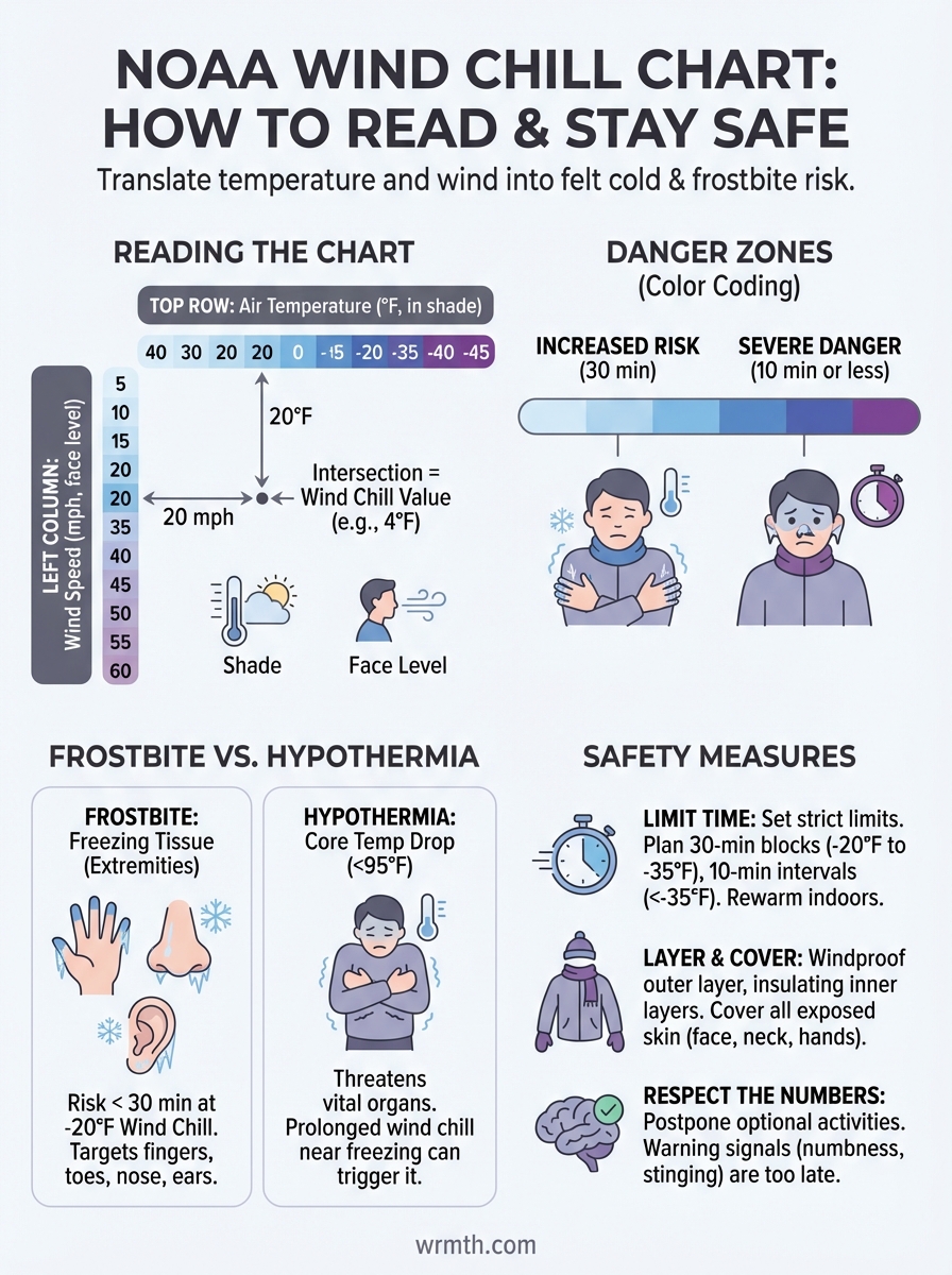
The NOAA wind chill chart is essentially a grid that translates two simple inputs (air temperature and wind speed) into one critical output: what the temperature actually feels like on exposed skin. You'll find temperature values running along the top row (typically from 40°F down to -45°F or lower) and wind speeds down the left column (usually from 5 mph up to 60 mph). Where these two axes intersect, you get your wind chill temperature.
The chart's core components
Your starting point is always the actual air temperature as measured in the shade, not in direct sunlight. Wind speed should be measured at face level, about 5 feet off the ground, since that's where your exposed skin sits when you're standing or walking. The chart's intersecting cells display the resulting wind chill temperature in the same units (Fahrenheit or Celsius depending on your version). These numbers tell you exactly how cold your skin will respond to the environment.
How temperature and wind speed combine
Wind accelerates heat loss from your body by stripping away the thin layer of warm air your skin naturally creates. At calm conditions, this invisible barrier provides some insulation. Once wind picks up beyond about 5 mph, that protection vanishes rapidly. You'll notice the chart shows diminishing returns at higher wind speeds: jumping from 5 mph to 20 mph creates a dramatic drop in wind chill, but going from 40 mph to 60 mph barely changes the number.
The wind chill effect stops mattering once you're fully bundled, since the formula assumes exposed skin as the reference point.
Color coding on most versions of the chart helps you quickly spot danger zones. Light blue shading typically indicates increased frostbite risk (30 minutes to onset), while darker blues and purples warn of severe danger where frostbite can develop in 10 minutes or less.
Why wind chill matters for frostbite and hypothermia
Your body maintains a constant internal temperature around 98.6°F, but wind chill accelerates heat loss from exposed skin at rates your natural defenses can't match. The noaa wind chill chart doesn't just tell you comfort levels, it predicts how quickly tissue damage and core temperature drops can occur. Understanding these timelines lets you plan outdoor activities with actual safety margins instead of guessing. Your skin begins losing its protective heat barrier the moment wind speeds exceed 5 mph, and the process compounds rapidly as both temperature drops and wind increases.
Frostbite develops faster than you think
Frostbite happens when skin tissue literally freezes, usually starting with fingers, toes, nose, and ears where blood flow is weakest. At a wind chill of -20°F, you face frostbite risk within 30 minutes of exposure on any unprotected skin. Drop to -35°F wind chill and that window shrinks to just 10 minutes. Severe wind chills below -50°F can cause frostbite in under 5 minutes, giving you almost no margin for error if you're caught unprepared or misjudge conditions.
Wind chill below -20°F means you should treat every minute outdoors as borrowed time for exposed skin.
Hypothermia threatens your core temperature
While frostbite attacks extremities, hypothermia targets your body's core, dropping your internal temperature below 95°F where vital organs begin failing. Wind chill speeds this process by pulling heat away from your torso and head faster than your metabolism can generate warmth. You don't need extreme cold for hypothermia to set in either. Prolonged exposure to wind chills near freezing (especially with wet clothing or after physical exertion) can trigger hypothermia within an hour, causing confusion, loss of coordination, and eventually unconsciousness.
How to read the NOAA wind chill chart step by step
Reading the chart correctly takes just three straightforward steps, but accuracy matters when safety decisions hang in the balance. You need two pieces of information before you start: the current air temperature and the sustained wind speed at face level. Both values should be current readings, not forecasts from hours ago, since conditions can shift rapidly during winter storms or cold fronts.
Step 1: Locate your current air temperature
Find the temperature row along the top of the chart that matches your thermometer reading. Most versions display temperatures in 5-degree increments, so if you're sitting at 17°F, you'll round to the nearest value (either 15°F or 20°F). The noaa wind chill chart uses actual air temperature measured in the shade, away from sun exposure or heat sources that could give false readings.
Step 2: Find the wind speed reading
Look down the left column for your wind speed, which should reflect sustained winds rather than brief gusts. Weather apps typically report both, so use the sustained number for accuracy. Wind speeds appear in 5 mph increments on most charts, requiring you to round if you're between values.
Step 3: Read the wind chill value
Trace your temperature column down and your wind speed row across until they intersect. That cell contains your wind chill temperature, the number that actually matters for planning outdoor time. Check the color coding at this intersection to identify your risk level for frostbite.
Always recheck conditions every 30 minutes when wind chill approaches danger thresholds, since rapid changes can catch you off guard.
Wind chill formula, limits, and common myths
The wind chill formula has evolved significantly since its first version appeared in the 1940s. Today's noaa wind chill chart uses an equation developed in 2001 that accounts for modern understanding of heat transfer and human physiology. The math itself is complex, involving exponential functions and multiple variables, but you don't need to memorize it. What matters is recognizing that this formula has built-in limitations and that several widespread beliefs about wind chill are completely wrong.
The current wind chill formula
Your weather service calculates wind chill using this 2001 revision: WC = 35.74 + 0.6215T - 35.75(V^0.16) + 0.4275T(V^0.16), where T represents air temperature in Fahrenheit and V represents wind speed in miles per hour. This formula only applies when temperatures drop below 50°F and wind speeds exceed 3 mph. Below these thresholds, your body doesn't experience meaningful wind chill effects worth calculating.
The formula assumes you're walking into the wind at about 3 mph, which is why calm conditions show wind chill equal to actual temperature.
Common misconceptions debunked
Wind chill cannot freeze objects or lower actual air temperature, it only describes how fast your body loses heat. A puddle of water won't freeze any faster at -10°F with 30 mph winds than it would at -10°F with no wind. Additionally, staying indoors with windows closed means wind chill becomes irrelevant, since the formula specifically measures exposed skin in moving air.
What to do on dangerous wind chill days
When the noaa wind chill chart shows values approaching -20°F or lower, your outdoor plans need immediate adjustments. These conditions demand proactive safety measures rather than simply toughing it out. Your body cannot maintain safe core temperature indefinitely when wind chill reaches dangerous levels, regardless of how well you think you tolerate cold. Every decision to stay outside carries measurable risk that compounds over time.
Limit outdoor exposure time
Set strict time limits based on chart color coding before you step outside. Wind chills between -20°F and -35°F mean you should plan outdoor activities in 30-minute blocks maximum, returning indoors to rewarm between sessions. Below -35°F wind chill, cut your exposure to 10-minute intervals and consider whether the trip is truly necessary.
Plan indoor breaks before you feel cold, since by the time numbness sets in, tissue damage may have already started.
Dress in layers with wind protection
Your outer layer needs to be windproof material like tightly woven nylon or polyester, since even thick wool allows dangerous air penetration. Layer underneath with insulating fabrics that trap warm air close to your skin. Cover every inch of exposed skin on your face, neck, and hands using masks, scarves, and insulated gloves rated for the conditions you're facing.
Staying warm and making smart calls
Understanding the noaa wind chill chart transforms winter safety from guesswork into informed decision-making. You now know how to read the intersecting values, recognize danger thresholds, and time your outdoor exposure before frostbite risks escalate. These skills protect you whether you're commuting to work, hiking mountain trails, or simply stepping outside to check the mail during a cold snap. Checking current conditions before every outdoor activity becomes second nature once you understand what the numbers actually mean for your safety.
Smart planning means respecting the numbers instead of testing your limits. When wind chill drops below safe levels, postpone optional outdoor activities or cut them short without hesitation. Your body's warning signals (numbness, stinging skin, confusion) often arrive too late to prevent damage.
For those determined to reclaim their outdoor spaces even during shoulder seasons and cooler evenings, heated outdoor furniture from wrmth delivers direct warmth that traditional patio heaters can't match. You'll stay comfortable on your deck or patio without constantly checking wind chill charts, extending your outdoor season safely and comfortably.